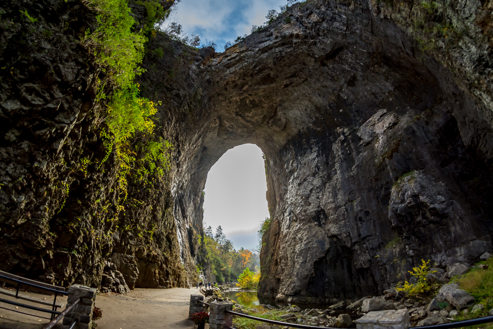
One of Virginia’s most amazing architectural treasures wasn’t formed by the hand of man at all, and it’s listed in the National Register of Historic Places. Thomas Jefferson once owned it. George Washington is said to have surveyed its location as a young lad of 17—though he was fully commissioned as a surveyor with a certification from the College of William & Mary. The future president, according to local lore, even carved his initials in the stone of it, though that story is simply not provable. Frederic Church made a painting of it as well.
Virginia’s Natural Bridge has stood, amazing those who have beheld it, since long before European settlers ever came to the Great Valley of Virginia. Spanning the limestone gorge of Cedar Creek in Rockbridge County, Virginia, the 215-foot-tall Natural Bridge today carries a U.S. highway, Route 11, across the chasm. It’s perhaps the only formation of its type to be listed as a highway bridge by the Virginia Department of Transportation.
Formed by the elements, Natural Bridge is all that remains of the roof of an ancient cavern, the bulk of which collapsed into Cedar Creek long ago. The first European to write about the bridge was John Peter Salling, who in 1742 was among five Virginia explorers departing from the region on a journey to the Mississippi River. Thomas Jefferson purchased the 157-acre tract of land that contains the bridge in 1774. The surveyor of record is James Tremble, though Washington may have worked for him. Interestingly enough, Tremble’s survey makes no mention of the Natural Bridge.

Jefferson himself spares no words in his “Notes on the State of Virginia” (1787) description:
The Natural Bridge, the most sublime of nature’s works, though not comprehended under the present head, must not be pretermitted. It is on the ascent of a hill, which seems to have been cloven through its length by some great convulsion. The fissure, just at the bridge, is by some admeasurements, 270 feet deep, by others only 205. It is about 45 feet wide at the bottom, and 90 feet at the top; this of course determines the length of the bridge, and its height from the water, its breadth in the middle is about 60 feet, but more at the ends, and the thickness of the mass at the summit of the arch, about 40 feet. A part of this thickness is constituted by a coat of earth, which gives growth to many large trees. The residue, with the hill on both sides, is one solid rock of lime-stone. The arch approaches the semi-elliptical form; but the larger axis of the ellipses, which would be the cord of the arch, is many times longer than the transverse. Though the sides of this bridge are provided in some parts with a parapet of fixed rocks, yet few men have resolution to walk to them, and look over into the abyss. You involuntarily fall on your hands and feet, creep to the parapet, and peep over it.
Bob Kirchman is an architectural illustrator who lives in Augusta County, Va., with his wife Pam. He teaches studio art, with a good deal of art history thrown in, to students in the Augusta Christian Educators Homeschool Coop. Kirchman is an avid hiker and loves exploring the hidden wonders of the Blue Ridge Mountains.